
WHR
Betws Garmon-Cae Hywel
area page
V3.33 updated 4/7/03
New images on this page updated 29/6/03.
Click here for start of new images
Click here for JC Sreeves latest construction map
Locations
The railway runs along the east
side of the A4085 from Betws Garmon station, crossing the Afon Gwyrfai. It
passes under OB53 (A4085) at Ch 7180. The railway now remains to the west of
the road behind the Water Works to the end of this section.
The formation is clearly visible from the
A4085 approaching OB53. There is a public footpath from Betws Garmon church
along the east side of the river that gives an alternative view of this
section.
Gradients
The route runs level from Betws
Garmon towards OB53 where there is small dip at 1 in 100 under the bridge. The
railway climbs at 1 in 60 through the Bryn Gloch caravan site and then falls at
1 in 1500 towards the Afon Gwyrfai bridge UB56.
Afon Gwyrfai Bridge
From Betws Garmon station, the railway immediately crosses the Afon Gwyrfai on a bowstring girder bridge 15 metres long. This was removed on 2/11/00 and is now stored in Dinas North yard.
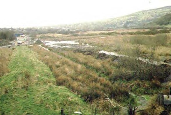
This southerly archive view shows the 15 m span bowstring girder bridge UB51 before its removal on November 2nd 2000. The wooden way beams were once retained by brackets. The bridge had carried a painted slogan 'Wot no railway?'. The formation can be seen crossing the floodplain beyond and passing under the A4085. Elephant Mountain is to the right. Click on the image to enlarge. This image is copyright B.W.Hughes. Slide scan technology utilised is Olympus ES10 & iPhoto Plus4. Slide scanned at 200dpi.
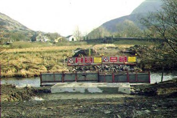
This southerly view (16/12/00) was taken on an official trackbed walk and shows the gap left by the removal of the 15 m span bowstring girder bridge UB51 on 2/11/00. Piling surrounds both abutments to allow work on them during the fish spawning season. Click on the image to enlarge. This image is copyright B.W.Hughes. Slide scan technology utilised is Olympus ES10 & iPhoto Plus4. Slide scanned at 200dpi.
This southerly view (19/5/01) shows the completed abutments of the Gwyrfai bridge (UB51). The piling has been removed and rock armour added to prevent scour. Local rock cladding has been added to give the re-inforced concrete bridge a more appropriate finish. There are two 60 cm square bearing pads in each corner of the structure for the bridge beams which will not be fitted until the Winter. Click on the image to enlarge. This image is copyright B.W.Hughes. Slide scanned at 200 dpi using Olympus ES10 and iPhoto Plus4 image correction technology.

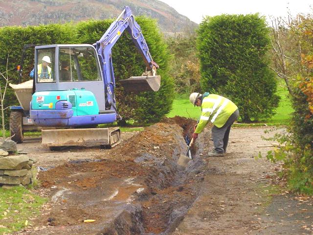
This southerly view (24/6/01) shows the Mulcair works to connect the new water main to the old to the left of the southern abutment of the Gwyrfai bridge (UB51). A deep piled excavation allows the two water mains to be exposed. From this view it is possible to see how close to the railway alignment the original water main ran. the new main is about 20 metres to the east (left). Click on the image to enlarge. This image is copyright B.W.Hughes. Slide scanned at 200 dpi using Olympus ES10 and iPhoto Plus4 image correction technology.
This northerly view (24/6/01) shows the northern abutment of UB 51 with the shell of Betws Garmon station behind the compressor. The abutment has been finished in local stone cladding like its southern twin. The foundations are also protected against river scour by rock armour. Click on the image to enlarge. This image is copyright B.W.Hughes. Slide scanned at 200 dpi using Olympus ES10 and iPhoto Plus4 image correction technology.

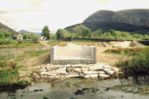
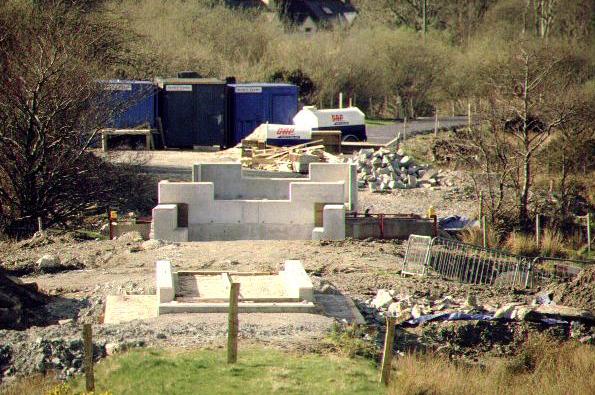
This northerly view (7/4/01) shows the completed foundations of the bridge. the bare concrete is already being clad in cosmetic local stop similar to that used on new structures in Phase 2. The track will pass through the notch in the top of the bridge. Click on the image to enlarge. This image is copyright B.W.Hughes. Slide scan technology utilised is Olympus ES10 & iPhoto Plus4. Slide scanned at 200dpi.
The abutments are complete for UB51 and await girders. The railway deck will be at the height of the 30 cm deep slots in the centre of the bridge. Some fill is necessary to raise the trackbed to the final levels between UB51 and UB52. The trackbed will be restored to the original levels.
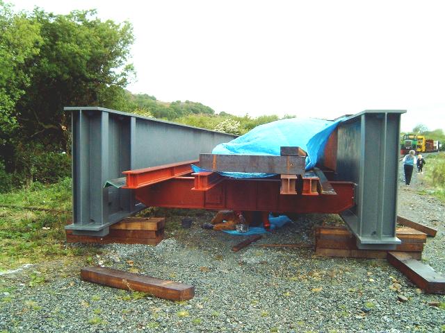
When the tenders were placed for UB51, the quotes came in around £80,000, some £30,000 above expectations. As a result, it was decided to investigate redundant BR bridges and a set of old BR bridge girders of a suitable size was found on a site being cleared for redevelopment near Rotherham.
The bridge girders were altered to fit, shot blasted, painted in undercoat and delivered with a saving of £60,000 to the project. At the end of May, volunteers were painting the girders at Betws Garmon.

This southerly view (18/5/03) shows the bridge erected at the south end of Betws Garmon station. Work was nearing completion on the first coat of epoxy grey paint protected from the rain by blue plastic sheeting. Click on the image to enlarge. This image is copyright B.W.Hughes. Image taken using Samsung Digimax 230 digital camera and post processed using iPhoto Plus4 image correction technology. Image displayed at 96dpi.
The bridge was first assembled on the north side of the river in Betws Garmon station. It was set up on wooden sleepers, aligned by laser and drawn together with temporary bolts. These are being replaced with High Strength Friction Grip (HSFG) bolts, which are, as the name suggests, quite special and are used in bridge construction to make a shake proof and robust connection. The bolts will fail prematurely if the threads are damaged, and they cannot be repeatedly tightened, loosened and tightened again.
This northerly view (18/5/03) shows the bridge erected at the south end of Betws Garmon station. Work was nearing completion on the first coat of epoxy grey paint. The waybeams and angle iron, for walkway edge supports, remain to be fitted and painted. Click on the image to enlarge. This image is copyright B.W.Hughes. Image taken using Samsung Digimax 230 digital camera and post processed using iPhoto Plus4 image correction technology. Image displayed at 96dpi.
Prior to fitting together, it was not known what tolerances the members had been fabricated to, and whether affected by rust, deformation of the mating surfaces, or misalignment of the holes. Usually these factors result in a lot of jiggling of the girders to get all 48 bolts to fit simultaneously and some bolts are tight while others require longer bolts to draw the mating surfaces together with force. Thus to avoid damage, cheaper, readily obtainable bolts are used for fitting together.
These will be replaced one at a time with HSFG bolts to make the permanent connection. The two types cannot be confused because they have different markings and have different size heads. To make absolutely sure, the temporary bolts have been fitted in reverse with the nuts on the outside, so at a glance it will be easy to ascertain when they have all been changed.
In the event, all of the bolts fitted easily. The holes are 15/16 inches and the bolts should be 7/8 in; dimensions being in accordance with the old imperial standards used by BR when the girders were constructed. Imperial size HSFG bolts are no longer available, so the WHLR had to use the nearest metric size, which is 22mm, albeit 2% smaller in area. Even 22mm bolts are non-preferred and took some time to obtain.
In the last week of May, the bridge was to receive its final epoxy grey coat and the waybeams and walkways were to be fitted. The bridge was to be lifted onto the abutments week ending 6/6/03.
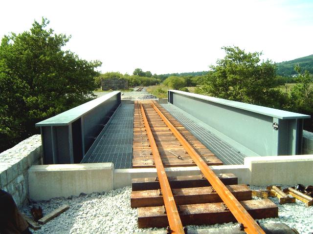
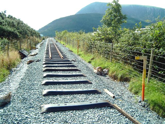
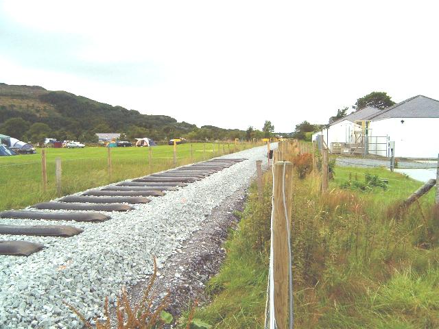
This northerly view (29/6/03) shows the bridge now in position with track in place but not screwed down to the base plates. Click on the image to enlarge. This image is copyright B.W.Hughes. Image taken using Samsung Digimax 230 digital camera and post processed using iPhoto Plus4 image correction technology. Image displayed at 96dpi.

This southerly view (29/6/03) shows the bridge with track in place ready to be joined up to track being laid from Bryn Gloch. Click on the image to enlarge. This image is copyright B.W.Hughes. Image taken using Samsung Digimax 230 digital camera and post processed using iPhoto Plus4 image correction technology. Image displayed at 96dpi.
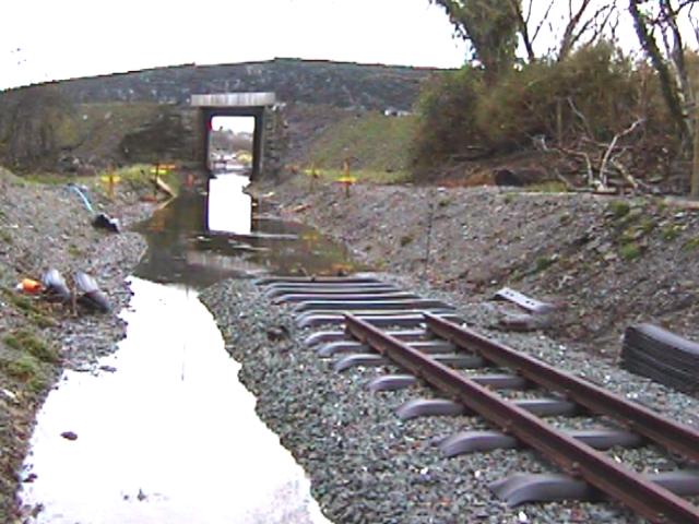
This southerly view (29/6/03) shows the link-up of track between OB51 and UB52. Click on the image to enlarge. This image is copyright B.W.Hughes. Image taken using Samsung Digimax 230 digital camera and post processed using iPhoto Plus4 image correction technology. Image displayed at 96dpi.
Flood relief bridge UB52
The railway runs across the floodplain on a 2 metre high embankment before crossing a flood relief bridge, UB52.
A plant road has been built from the A4085 gate at the location shown below, across the overflow channel to access the trackbed between UB52 (spillway) and UB51, the removed bowstring bridge.

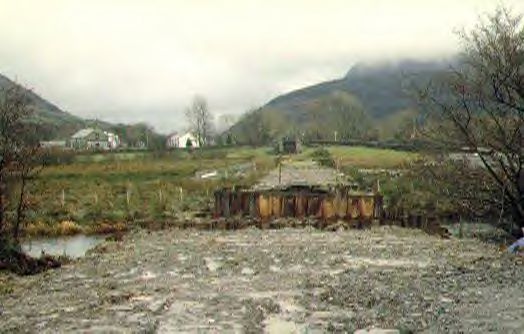
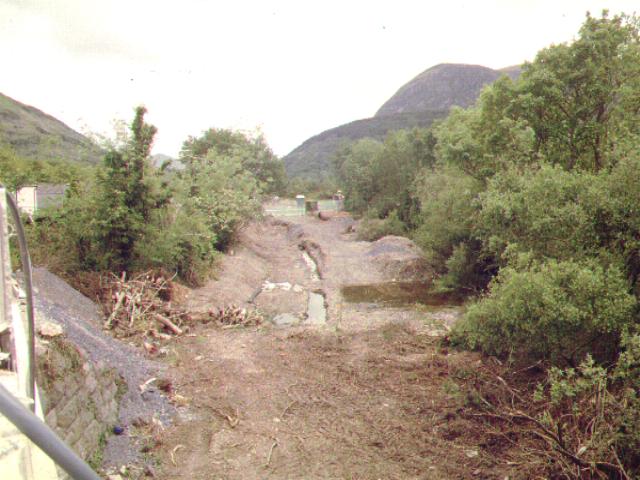
This northerly view (28/10/00) shows flood relief channel in action through UB52, with the rusty brown bowstring bridge behind. UB 51 was removed on 5 days later and will be replaced with a few months with a new structure. This is the view from the main road. Click on the image to enlarge. This image is copyright B.W.Hughes. Slide scan technology utilised is Olympus ES10 & iPhoto Plus4. Slide scanned at 200dpi.
When Triact examined the flood relief bridge they found a major problem. The bridge had no proper foundations and the slate slab deck merely distributed the rolling weight of the loco over the six piers founded in boggy marsh. The structure was not up to modern standards and the solution was to build two new concrete piers either end and float a concrete beam over the central four piers. This would allow the bridge to retain its appearance, though the central four piers would only have a cosmetic role.
This easterly view (19/2/01) shows excavations either side of UB52 for the new abutments leaving the four central piers intact. Click on the image to enlarge. This image is copyright B.W.Hughes. Slide scan technology utilised is Olympus ES10 & iPhoto Plus4. Slide scanned at 200dpi.
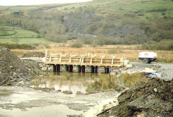
This easterly view (7/4/01) shows UB52 in an advanced state of construction. The new outer piers are now complete and formwork is in place for the new cast deck beam. This will be clad in local stone to blend in as have the abutments for UB51. Click on the image to enlarge. This image is copyright B.W.Hughes. Slide scan technology utilised is Olympus ES10 & iPhoto Plus4. Slide scanned at 200dpi.
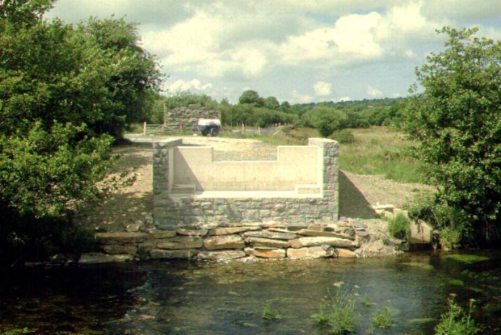
This easterly roadside view (19/5/01) shows UB52 now completed and clad in local stone. The caps tones are gabled for effect. Click on the image to enlarge. This image is copyright B.W.Hughes. Slide scanned at 200 dpi using Olympus ES10 and iPhoto Plus4 image correction technology.
This easterly view (24/7/01) shows how the new deck of UB52 does not rest on the original piers which have been retained for aesthetic reasons only. The original stone lintel hides the fact that the re-inforced concrete deck is suspended some 20 cm above the piers. The spillway channel has also been concreted between the piers to protect against floodwater scouring. Click on the image to enlarge. This image is copyright B.W.Hughes. Slide scanned at 200 dpi using Olympus ES10 and iPhoto Plus4 image correction technology.
This northerly view (24/6/01) shows a close-up of the new cast concrete deck of UB52, lying within the original parapet. When the 30 cm deep ballast bed is laid, the rail top will be about the same height as the top of the parapets. Click on the image to enlarge. This image is copyright B.W.Hughes. Slide scanned at 200 dpi using Olympus ES10 and iPhoto Plus4 image correction technology.
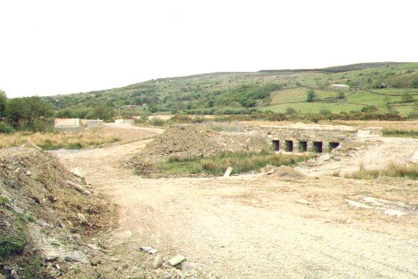
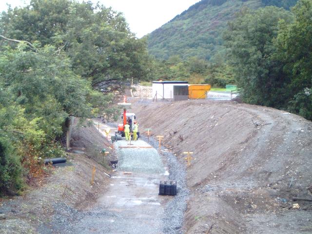
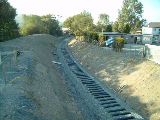
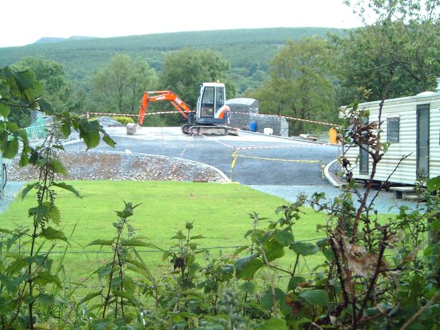
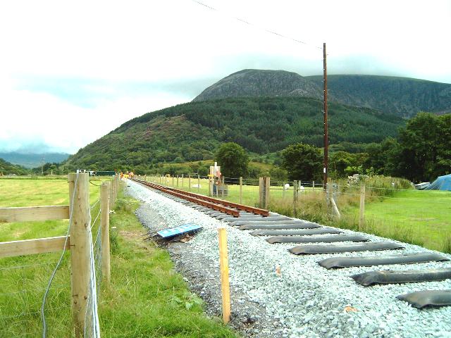
This easterly view (30/6/02) of the trackbed just north of UB52 shows the excavator rebuilding the formation with slate waste to its normal height. Click on the image to enlarge. This image is copyright B.W.Hughes. Image taken using Samsung Digimax 230 digital camera and post processed using iPhoto Plus4 image correction technology. Image displayed at 96dpi.
This northerly view (30/10/02) of the trackbed just north of OB53 shows the graded formation with slate fines dipping under the bridge. It is hoped to advance the tracklaying from Bryn Gloch when the formation works are completed this Winter. Click on the image to enlarge. This image is copyright B.W.Hughes. Image taken using Samsung Digimax 230 digital camera and post processed using iPhoto Plus4 image correction technology. Image displayed at 96dpi.

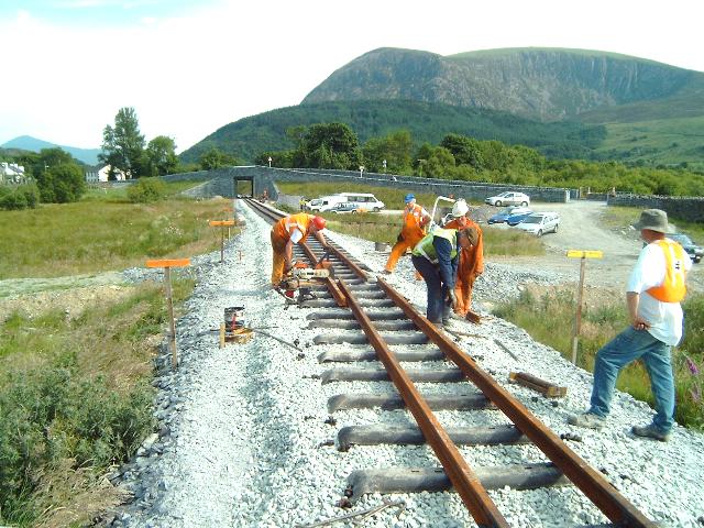
This northerly view (29/6/03) shows Harold propelling rails towards Betws Garmon bridge to close the gap. Click on the image to enlarge. This image is copyright B.W.Hughes. Image taken using Samsung Digimax 230 digital camera and post processed using iPhoto Plus4 image correction technology. Image displayed at 96dpi.
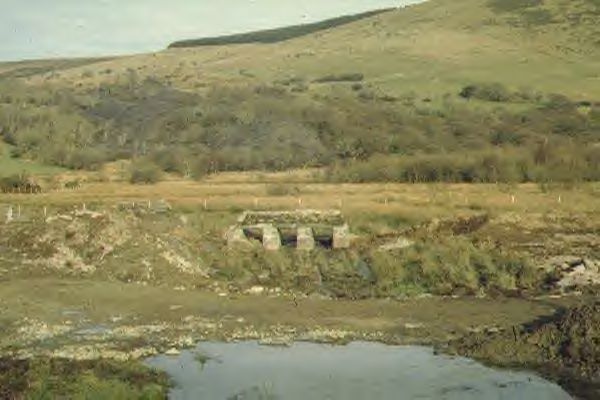
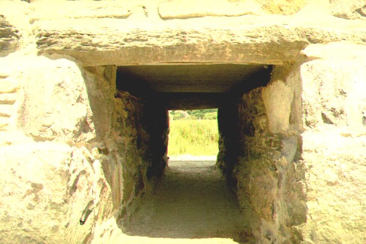
A4085 Bridge (OB53)
The railway passes under the A4085 at this point in an unusual bridge with a flat deck beam and galvanised steel sheeting sides.
In a recent change, GCC has advised the WHLR that it is to rebuild OB53 to improve the weight restricted bridge. Any widening would require the abutments to be lengthened along the railway alignment by a proportionate amount. The form of the rebuild has not yet been advised.
A new cast concrete deck is to be provided reducing the current weight restriction upon the bridge. GCC has already re-pointed the Castell Cidwm bridge OB71 and the Pitt's Head bridge OB123 last Autumn. The idea is to get the work done on OB53 before the railway opens in Summer 2002, thus causing less disruption.
Gwynedd Council is widening the bridge on the north side which will include the ramps. The existing abutments are being lengthened at the same width as perceived from the railway track. GCC is to use the existing 'De Winton' cast iron beams under the parapet of the widened bridge. The parapet will be stone clad and conform to current day standards. The existing deck of cast iron beams with brick arches between them (jack arches) will be replaced by a reinforced concrete deck. In these circumstances the two end cast iron beams will become decorative only.
Work started on 22/10/01 and will take several months. It is likely to be finished in September 2002. The WHLR reached agreement with Gwynedd Structures (GCC) with regard to taking 60 foot articulated rail carrying lorries over OB53 at Bryn Gloch. This weak bridge had a 17 tonne weight limit restriction added from May 2001. Rather than take full loads of 33 rails (19.8 tonnes net), the WHLR will be taking 22 rails max giving an axle load acceptable to Gwynedd Structures. Ballast for the tracklaying at Rhyd Ddu came from Penmaenmawr, being 55p/tonne more expensive to go the long way round, missing the 17 tonne weight limit until the bridge was completed in Summer 2002.
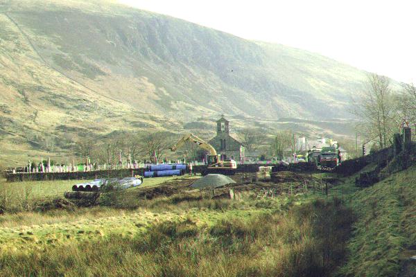
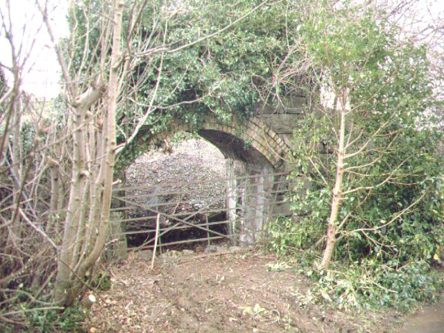
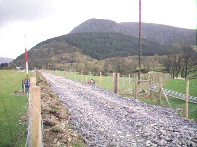
This southerly archive view shows the sharp skew angle of OB53 and the long retaining wall required on the west side at the north end. This is matched by a similar wall on the east side at the south end. Click on the image to enlarge. This image is copyright B.W.Hughes. Slide scanned at 200 dpi using Olympus ES10 and iPhoto Plus4 image correction technology.
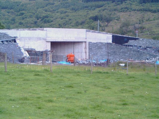
This westerly view (30/6/02) of the north face of the bridge shows the cladding operation nearing completion. Riven slate is being used to clad the re-inforced concrete walls. A grey local stone is being used to clad the railway slot. Click on the image to enlarge. This image is copyright B.W.Hughes. Image taken using Samsung Digimax 230 digital camera and post processed using iPhoto Plus4 image correction technology. Image displayed at 96dpi.
This westerly view (24/8/02) from the public footpath at Betws Garmon church shows the cladding completed on the north face and the black de Winton girder clearly visible. Work is still underway adding the sharp slate on the parapet to deter climbing. Progress on the south face had not advanced to adding the girder. Click on the image to enlarge. This image is copyright B W Hughes. Image taken on Samsung Digimax230 digital camera using iPhoto Plus4 image correction technology. Image displayed at 96dpi.

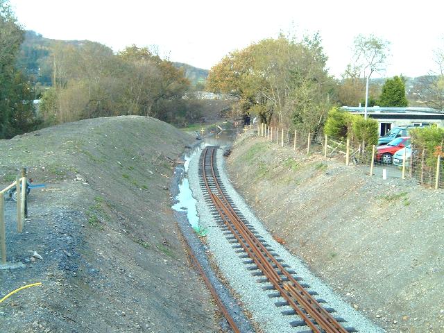
This southerly view (30/10/02) of the trackbed just north of OB53 shows the graded formation with slate fines dipping under the bridge. This led to an accumulation of water during the Autumn that will only be remedied when a deep drain is cut through the bridge slot. The water will then drain to the ditch to the left. Click on the image to enlarge. This image is copyright B.W.Hughes. Image taken using Samsung Digimax 230 digital camera and post processed using iPhoto Plus4 image correction technology. Image displayed at 96dpi.
GCC contractors were on site in early December removing the recently erected cladding on the west abutment, which found to be slightly foul of the new wider loading gauge. This was soon put right with thinner cladding blocks. Attention must then have switched to draining the site and on 23/12/02 a contractor was tidying up the landscaping north of the bridge and the dip under the bridge was completely dry.
This will permit the ballasting to go ahead to the end of the formation at Bryn Gloch. Ballasting should follow promptly during January 2003 and this should permit tracklaying over the short gap from Ch.7240 at Bryn Gloch to Betws Garmon bridge at Ch.7000.
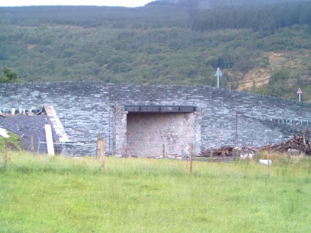
This southerly archive view shows the detail of the decaying metalwork of OB53. The jack arch (brick arches on cast iron beams) structure supporting the roadway is weak and the bridge had a 17.5 weight limit imposed on it in May. GCC intends rebuilding the bridge this Autumn, to be completed within six months. The de Winton girders under the parapets will be retained for decorative purposes only. The bridge height may be just sufficient for the WHR loading gauge but the opportunity may be taken to raise it a little to avoid the need to underpin the foundations. Click on the image to enlarge. This image is copyright B.W.Hughes. Slide scanned at 200 dpi using Olympus ES10 and iPhoto Plus4 image correction technology.
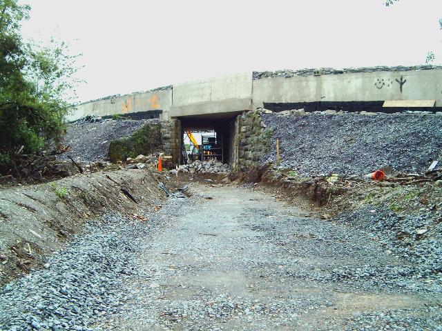
By March, Jones Bros was on site adding a deep drain through the bridge and adding re-inforced concrete haunches to support the abutments of the original section of the bridge. A reinforced concrete base braces the abutments. Jones Bros. cleared the site by mid-May.
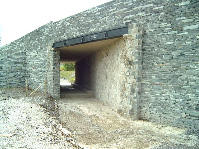
This southerly view (18/5/03) shows the north portal of the bridge. A deep drain exits the deepened formation to the near left. The step of the reinforced concrete base can be seen within the bridge slot. Click on the image to enlarge. This image is copyright B.W.Hughes. Image taken using Samsung Digimax 230 digital camera and post processed using iPhoto Plus4 image correction technology. Image displayed at 96dpi.
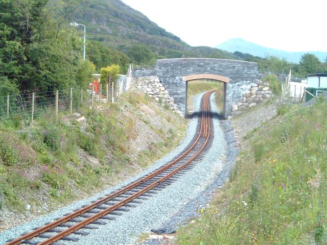
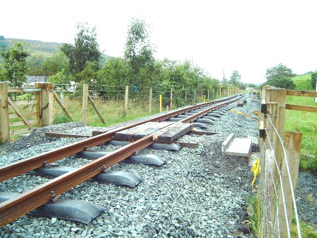
This southerly view (29/6/03) shows the track completed through Pont Betws. Click on the image to enlarge. This image is copyright B.W.Hughes. Image taken using Samsung Digimax 230 digital camera and post processed using iPhoto Plus4 image correction technology. Image displayed at 96dpi.
This southerly view (18/5/03) shows the reinforced concrete base and haunch supports. these have only been fitted to the original NWNGR section of the bridge as the trackbed has been deepened for the new loading gauge and the foundations exposed. Click on the image to enlarge. This image is copyright B.W.Hughes. Image taken using Samsung Digimax 230 digital camera and post processed using iPhoto Plus4 image correction technology. Image displayed at 96dpi.
This northerly archive view of OB53 shows the overgrown south face of the bridge from the Bryn Gloch side. Click on the image to enlarge. This image is copyright B.W.Hughes. Slide scanned at 200 dpi using Olympus ES10 and iPhoto Plus4 image correction technology.
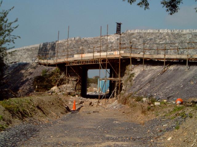
This northerly view from the scaffolding bridge (7/4/02) shows the south face of Pont Betws just days before it was demolished to construct the new deck. Click on the image to enlarge. This image is copyright B.W.Hughes. Slide scanned at 200 dpi using Olympus ES10 and iPhoto Plus4 image correction technology.
This northerly view (2/8/02) of OB53 shows little progress in cladding the bridge considering the time taken. The de Winton girder has not yet been erected. work is clearly still underway on the local stone cladding in the railway slot. The formation has been excavated to its new lower level to provide clearance for the larger loading gauge of modern rolling stock. Click on the image to enlarge. This image is copyright B W Hughes. Image taken on Samsung Digimax230 digital camera using iPhoto Plus4 image correction technology. Image displayed at 96dpi.
This northerly view (18/5/03) shows the south face of the bridge with the new reinforced concrete base bracing the original abutments. Haunch supports are also visible with additional supports to the wing walls. Click on the image to enlarge. This image is copyright B.W.Hughes. Image taken using Samsung Digimax 230 digital camera and post processed using iPhoto Plus4 image correction technology. Image displayed at 96dpi.
Although the roadway aspects of the bridge were completed and opened in early July, cladding dragged on slowly until September. The WHLR had to wait for the site to be released so they could finish the short section of trackbed through the bridge. Jones Bros. started ballasting south of the bridge from 2/8/02. Ballasting could be completed from a dump at UB52 from Bryn Gloch back through OB53 to UB52 and rail extended north from OB54.

This easterly view (4/6/02) shows the refurbished De Winton girders back on site, ready for fitting to the bridge. The girders have been cleaned up and painted black while the lettering is picked out in white. The girders will be applied to the two faces of the bridge for cosmetic purposes. A concrete ledge has been formed in the deck beam to accommodate them. Click on the image to enlarge. This image is copyright B.W.Hughes. Image from Sigma SA300 SLR camera. images scanned at 200dpi using Olympus ES10 and iPhoto Plus4 image correction technology. Image displayed at 96dpi.
UB53 roadworks have now been archived. Click on this link to view the bridgeworks.
Water Main diversion
Although Triact has been on site since October, and has removed the bowstring bridge, it cannot start work south of UB52 until Hyder (Welsh Water) moves the Caernarfon Water Main off the trackbed. The main was only placed on the trackbed in 1995 when it was still uncertain that the WHR project would go ahead.
Work started on the water main on 15/2/01 with a site being prepared next to the graveyard for pipe storage. Hyder has appointed Laing as its Project Managers though a local contractor, Mulcair, was called in to do the work on the ground.
On 19/2/01, a deep trench was dug parallel to the trackbed and some 20 metres to the east for the new pipe run. The pipe had been laid and the trench had been backfilled by 7/4/01.
By the end of June, work was focussed on diverting the pipe diagonally across the main road between the entrance to the graveyard and the Bryn Gloch footpath. In July, work carried through Bryn Gloch to the boundary of the Waterworks. The trench was rapidly re-turfed so that the campsite would not lose trade.
The pipeline pit shuttering adjacent to the south abutment of UB51 was removed by mid August. It had been necessary to join the pipes and it appeared that all the pipeline works were complete.
This northerly view (23/10/00) shows the trackbed from OB53, the main road. The water main runs along the east side of the line and is to be moved to a new route following the main road. Progress on this section is dependent on the rapid completion of the Hyder contract. In the distance on the east side of the trackbed, an exploratory opening has been made to identify the position of the water main. Click on the image to enlarge. This image is copyright B.W.Hughes. Slide scan technology utilised is Olympus ES10 & iPhoto Plus4. Slide scanned at 200dpi.
This northerly view (27/10/01) shows the GCC worksite on the trackbed north of OB53. A site road has been constructed from the road to the railway embankment. The new road bridge is to be widened to the north and the slope profile posts for the new embankment can be seen in the centre. Click on the image to enlarge. This image is copyright B.W.Hughes. Slide scan technology utilised is Olympus ES10 & iPhoto Plus4. Slide displayed at 96dpi.
This northerly view (7/4/01) shows the progress made over six weeks as seen from OB53, the A4085 road bridge. The new water pipes lie buried in the deep trench approx. 20 metres to the east of the trackbed. Work can be seen in the distance on both the flood relief channel UB52 and the Gwyrfai bridge piers UB51. Click on the image to enlarge. This image is copyright B.W.Hughes. Slide scan technology utilised is Olympus ES10 & iPhoto Plus4. Slide scanned at 200dpi.
This southerly view (15/4/01) taken from the main road shows the untouched WHR trackbed in the foreground as a grassy bank approaching OB53 on the right. Hyder had delivered large numbers of blue coated pipes to the storage compound next to Betws Garmon church since 7/4/01. This is the second major delivery. Click on the image to enlarge. This image is copyright B.W.Hughes. Slide scan technology utilised is Olympus ES10 & iPhoto Plus4. Slide scanned at 200dpi.
South of OB53
This southerly view (15/4/01) from the road bridge towards Bryn Gloch shows that some preliminary clearance had taken place before the F&M restrictions came into force. This was to allow access by survey teams for potential contractors to prepare their tenders. Following an announcement by the WHLR on 4/4/01, this process was suspended until further late 2001. Click on the image to enlarge. This image is copyright B.W.Hughes. Slide scan technology utilised is Olympus ES10 & iPhoto Plus4. Slide scanned at 200dpi.
This southerly view (9/2/02) shows the view from the temporary footbridge at OB53 looking towards OB54. This image was taken shortly after all the trees on the trackbed were chopped down ahead of the bird-nesting season tree when felling is prohibited. The WHR land strip is unusually wide here as there is a wide ditch to the right of the trackbed. Click on the image to enlarge. This image is copyright B.W.Hughes. Slide scanned at 200 dpi using Olympus ES10 and iPhoto Plus4 image correction technology.

This southerly view (23/2/02) shows the work taking place at OB54 from OB53. On this date the felled trees on this section had still to be cleared. An unusually wide strip of land between the two, some 100m long, has been suggested by some as the location for a future halt but a 'borrow pit' to the right has left a trench to be filled. Click on the image to enlarge. This image is copyright B.W.Hughes. Image captured from Hitachi D8 camcorder. Post processing by iPhoto Plus4. Image displayed at 96dpi.

This southerly view (2/3/02) shows the situation a week later with all the wood now cleared. The flooded borrow pit (right) alongside the trackbed is now clearly visible. One suggestion is that this location may receive some excess rock from the excavation of the new station alignment at Rhyd Ddu. Click on the image to enlarge. This image is copyright B.W.Hughes. Image captured from Hitachi VM-D865LE using Studio DV and iPhoto Plus4 image correction technology.

This southerly view (1/4/02) shows the situation with the trackbed re-graded. the slight downhill slope allow the caravan park bridge to be a much lower hump than might otherwise be the case. Click on the image to enlarge. This image is copyright WHLR, courtesy Jan Woods. Imaging technology utilised is iPhoto Plus4 image correction technology.
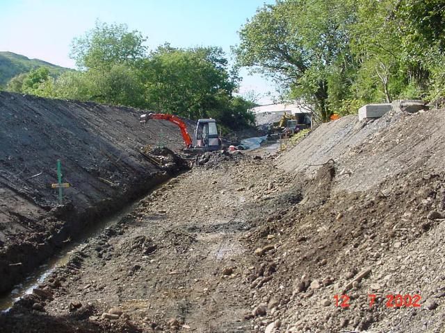
This southerly view (4/6/02) shows the construction of a drainage ditch on the west side of the formation south of OB53. Click on the image to enlarge. This image is copyright B.W.Hughes. Image from Sigma SA300 SLR camera. images scanned at 200dpi using Olympus ES10 and iPhoto Plus4 image correction technology. Image displayed at 96dpi.
While the bridge works are taking place a temporary parallel scaffold footbridge is being used on the south side as was in use for a period during the Cae Moel river diversion (Phase2). The new footbridge was constructed in early November and in use by November 11th.
Progress was made with undergrowth clearance of the trackbed on the southern (Bryn Gloch) side of the bridge and by 9/2/02, all trees on the trackbed had been cut down ahead of the bird nesting season when tree felling is prohibited.
Traffic control was in operation, with removal of the old roadside walls underway. The scaffold bridge allowed a view of the southern face of OB53, largely invisible for many years. Traffic control persisted for some time as the deck beams of OB53 are removed during the Spring and replaced by concrete beams.
This southerly view (2/8/02) from OB53 shows the start of ballasting through Bryn Gloch. Ballast commences at Ch.7245. Click on the image to enlarge. This image is copyright B W Hughes. Image taken on Samsung Digimax230 digital camera using iPhoto Plus4 image correction technology. Image displayed at 96dpi.

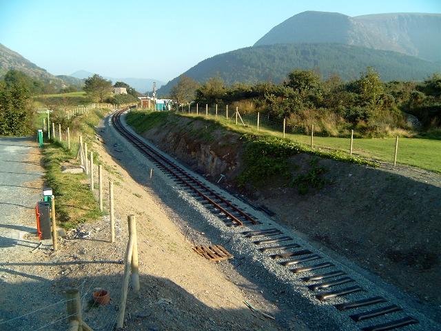
This southerly view (30/10/02) of the trackbed just south of OB53 shows the Head of Steel at Ch.7240. The need to deepen the formation under the bridge for the new larger loading gauge has led to an accumulation of water during the Autumn that will only be remedied when a deep drain is cut through the bridge slot. Click on the image to enlarge. This image is copyright B.W.Hughes. Image taken using Samsung Digimax 230 digital camera and post processed using iPhoto Plus4 image correction technology. Image displayed at 96dpi.
This southerly view (28/6/03) shows the track now completed through Bryn Gloch. On this day rails were being ferried to Betws Garmon bridge from Plas-y-nant. Click on the image to enlarge. This image is copyright B.W.Hughes. Image taken using Samsung Digimax 230 digital camera and post processed using iPhoto Plus4 image correction technology. Image displayed at 96dpi.
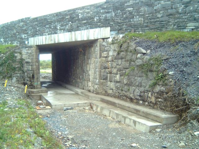
This northerly view (14/9/02) shows the completed OB53. Only the De Winton girder and the angled slate-coloured concrete slabs capping the parapet were needed to finish the job. The trackbed is likely to be released by the builders by late September after the scaffolding has been demolished. Click on the image to enlarge. This image is copyright B.W.Hughes. Image taken on Samsung Digimax 230 digital camera using iPhoto Plus4 image correction technology and displayed at 96dpi.
This northerly view (30/11/02) shows OB53 complete except for the fitting of the De Winton beam. A low point in the trackbed here has caused accumulation of water which will only be remedied when the trackbed is completed through the bridge. Click on the image to enlarge. This image is copyright B.W.Hughes. Image captured from Hitachi VM-D865LE using Studio DV and iPhoto Plus4 image correction technology.
Bryn Gloch
The trackbed is overgrown initially and then crosses between the caravan park and Bryn Gloch club house. A new bridge is to be constructed here at Ch. 7300 with the design sufficient to allow caravans to cross. Strangely, the owner has rejected the suggestion of a halt here despite the obvious business it would bring. Apparently, the owner wants the railway hedged in throughout his caravan site so that it cannot be seen!
Work was due to start on 1/11/01 but Triact found they were over-committed and so the WHLR appointed Jones Bros. of Ruthin instead. Jones Bros. did much of Phase 2 trackbed work. The work started on 7/1/02 and is proceeding north from Jones Bros. base at the north end of Cae Hywel bridge from a worksite known as Tros-y-Gol.
The first job was clearance of fly-tipping, which had taken place on the trackbed by persons unknown until late last year. Vegetation was cleared including cutting down 60 years of tree growth ahead of the bird nesting season, when there is a closed season on tree felling. The trackbed south from OB54 through the Bryn Gloch campsite was then consolidated with quarry waste. Previous stone supplies have been trucked in from Dorothea quarry in Nantlle.
Work on the new caravan site bridge was underway in mid February. The excavations for the both abutment footings were excavated by 17/2/01. The caravan site access road was diverted to north of the old OB54 and the western ramp of the old bridge was excavated prior to demolition.
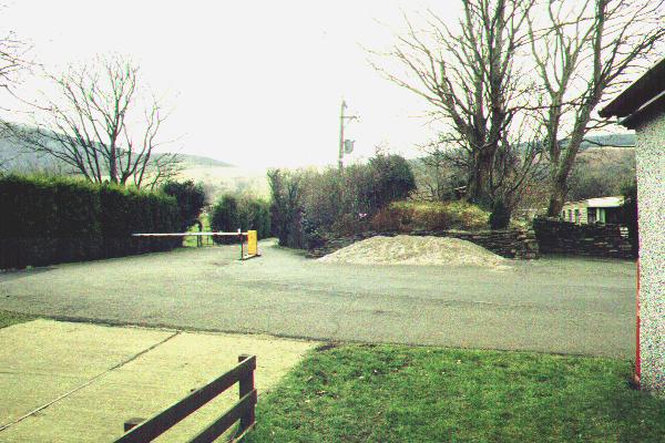
This westerly archive view was taken from the main road looking along the footpath through Bryn Gloch. The WHR alignment follows the line of large trees right to left. The old bridge OB54 still stands to the right of the barrier. The railway runs in a shallow cutting about a metre deep at this location. The new bridge will be immediately to the left of the barrier. Click on the image to enlarge. This image is copyright B.W.Hughes. Slide scan technology utilised is Olympus ES10 & iPhoto Plus4. Slide scanned at 200dpi.
This southerly view (15/11/01) shows the diversion of the water supply at Bryn Gloch caravan park prior to the construction of the new OB54, which was due to start the following week. the trackbed can be seen through the gap in the bushes. The new bridge will be immediately to the south of the current access road seen in this view. This view is copyright WHLR, courtesy Jan Woods. Imaging technology utilised is iPhoto Plus4. Slide displayed at 96dpi.
This is a northerly archive view from the public footpath through Bryn Gloch looking through the arch of the much overgrown OB54. This bridge will be demolished in due course and the stone could be re-used in the proposed Tryfan Junction station building volunteer restoration project. Click on the image to enlarge. This image is copyright B.W.Hughes. Slide scan technology utilised is Olympus ES10 & iPhoto Plus4. Slide scanned at 200dpi.
This northerly view (9/2/02) from the public footpath shows the bridge OB54 with undergrowth cleared prior to demolition. A quarry waste rock pile is visible north of the bridge in preparation for the temporary diversion of the caravan site access to the north of OB54. Click on the image to enlarge. This image is copyright B.W.Hughes. Slide scanned at 200 dpi using Olympus ES10 and iPhoto Plus4 image correction technology.
This southerly view (9/2/02) from the public footpath shows the formation cleared through the site of the new overbridge. Quarry waste has been added almost up to public footpath/caravan park access to firm up the formation. The location of the bridge will be about 20m south of this point. Warning tape either side of the trackbed marks the location of the new bridge. The consolidated trackbed will be used as an access road for the bridge construction to avoid disturbing the campsite. This image is copyright B.W.Hughes. Slide scanned at 200 dpi using Olympus ES10 and iPhoto Plus4 image correction technology.
This northerly view (19/2/02) shows the excavation of the large flooded hole just south of the old OB54 for the footings for the abutments for the new bridge. The old bridge is visible covered in ivy. The large diameter pipe is the remains of the original Caernarfon water main. Click on the image to enlarge This image is copyright WHR, courtesy Jan Woods using iPhoto Plus4 image correction technology.
This southerly view (23/2/02) shows the situation a few days later when vertical reinforcing rods rise from the site of the two abutments either side of the railway. The extra depth is necessary because of the nature of the ground which appears to be unconsolidated glacial till at this location. Click on the image to enlarge. This image is copyright B.W.Hughes. Image captured from Hitachi D8 camcorder. Post processing by iPhoto Plus4. Image displayed at 96dpi.
This southerly view (1/3/02) shows the situation a few days later when the trackbed slab was being cast. The vertical reinforcing rods rise from the site of the two future bridge abutments either side of the railway alignment. Click on the image to enlarge. This image is copyright WHLR, courtesy Jan Woods. Post processing by iPhoto Plus4. Image displayed at 96dpi.
This northerly view (7/4/02) shows the arched structure of the bridge appearing. The deck slab was cast the following week. Click on the image to enlarge. This image is copyright B.W.Hughes. Slide scanned at 200 dpi using Olympus ES10 and iPhoto Plus4 image correction technology.
This northerly view (4/5/02) shows the final stages of completion of the new OB54. The variegated riven slate cladding is nearly complete. The bridge has four courses of yellow brick in the arch facing. Click on the image to enlarge. This image is copyright B.W.Hughes. Image from Sigma SA300 SLR camera iPhoto Plus4 image correction technology and displayed at 96dpi.

This northerly view (19/6/02) of the south face of the bridge shows the cladding operation complete with four courses of yellow brick. Riven slate is being used to clad the re-inforced concrete walls. Click on the image to enlarge. This image is copyright WHR, courtesy Jan Woods. Image post processed using iPhoto Plus4 image correction technology. Image displayed at 96dpi.
This easterly view (25/6/02) of the area north of the bridge shows the excavation of the cutting. The cutting will be completed to the north when the road in diverted over the bridge in July. Click on the image to enlarge. This image is copyright WHLR, courtesy Jan Woods. Image post processed using iPhoto Plus4 image correction technology. Image displayed at 96dpi.

This northerly view (12/7/02) shows the cutting being excavated north of the bridge as viewed through the bridge arch. A cess is being installed on the left hand side. Spare material is being embanked on the west side north of the bridge as a noise barrier for the campsite. Click on the image to enlarge. This image is copyright WHLR, courtesy Jan Woods. Image post processed using iPhoto Plus4 image correction technology and displayed at 96dpi.
This southerly view (14/9/02) shows the completed tracklaying almost reaching OB54. Unusually, steel sleepers will be used through this bridge as it is built to wider modern standards and check rails are not required.. Click on the image to enlarge. This image is copyright B.W.Hughes. Image taken on Samsung Digimax 230 digital camera using iPhoto Plus4 image correction technology and displayed at 96dpi.
This northerly view (2/8/02) of OB54 shows the local stone cladding of the remaining exposed concrete and breezeblock faces. The stone used is probably the remains of the old bridge. Three strands of wire surmount the approach walls. New 10m marker posts have been erected. Click on the image to enlarge. This image is copyright B W Hughes. Image taken on Samsung Digimax230 digital camera using iPhoto Plus4 image correction technology. Image displayed at 96dpi.
This northerly view (12/7/02) shows the completed excavation of the cutting north of the OB54 where the temporary access road crossed the alignment. Spare spoil has been banked on the west side of the railway to form a noise barrier. Click on the image to enlarge. This image is copyright WHLR, courtesy Jan Woods. Image taken using a digital camera and post processed using iPhoto Plus4 image correction technology. Image displayed at 96dpi.
This northerly view (2/8/02) from the public footpath at OB54 shows good progress after one day of ballasting. Packs of sleepers have also been placed on the trackside for when WHLR volunteers start tracklaying. Click on the image to enlarge. This image is copyright B W Hughes. Image taken on Samsung Digimax230 digital camera using iPhoto Plus4 image correction technology. Image displayed at 96dpi.
This northerly view (14/9/02) shows sleepers laid north of OB54 from the bridge. Click on the image to enlarge. This image is copyright B.W.Hughes. Image taken on Samsung Digimax 230 digital camera using iPhoto Plus4 image correction technology and displayed at 96dpi.
By 4/6/02, the trackbed has been finished with rolled slate fines south from OB54 though the bridge itself had not yet been brought into use. The temporary Bryn Gloch access made it difficult to complete the works north of the bridge to OB53. The trackbed through Bryn Gloch was finished by the end of July and ballast was laid from south of OB53 back towards Cae Hywel allowing volunteer tracklayers onto this 1km section from August.
This northerly view (30/10/02) shows the completed tracklaying north of OB54 from the bridge. The flooding at this low point will not be remedied until the drainage through OB53 is completed. Click on the image to enlarge. This image is copyright B.W.Hughes. Image taken on Samsung Digimax 230 digital camera using iPhoto Plus4 image correction technology and displayed at 96dpi.
This southerly view (15/3/02) shows the deep cutting south of the OB54. At this point the railway has been excavated by up to 2m in rock to reduce the rise of the new bridge this easing the passage of caravans. The railway rises at 1 in 40 out of this dip. the rock excavated has been used to construct the new access road to the Cae Hywel house so that the owners can have road access when Cae Hywel railway bridge is returned to railway use. Click on the image to enlarge. This image is copyright WHLR, courtesy Jan Woods. Post processing by iPhoto Plus4. Image displayed at 96dpi.

This southerly view (24/8/02) from the public footpath over OB54 shows ballasting completed and packs of steel sleepers laid out. The 20m posts have been strangely demolished. Packs of sleepers have also been placed on the trackside for when WHLR volunteers start tracklaying. By the following day track was visible approaching around the corner from the south. Tracklaying should be complete to the end of ballast between OB54 and OB53 by the end of September. Click on the image to enlarge. This image is copyright B W Hughes. Image taken on Samsung Digimax230 digital camera using iPhoto Plus4 image correction technology. Image displayed at 96dpi.
This southerly view (14/9/02) shows Head of Steel just south of OB54 from the bridge. Track was expected to be laid through the bridge by 22/9/02 to the end of the available trackbed near OB53. Click on the image to enlarge. This image is copyright B.W.Hughes. Image taken on Samsung Digimax 230 digital camera using iPhoto Plus4 image correction technology and displayed at 96dpi.
This westerly roadside view (30/6/02) of the east ramp of the bridge shows the road alterations nearing completion. The bridge is wide enough for two vehicles to cross. Click on the image to enlarge. This image is copyright B.W.Hughes. Image taken using Samsung Digimax 230 digital camera and post processed using iPhoto Plus4 image correction technology. Image displayed at 96dpi.
This northerly view (15/9/01) shows the trackbed at Ch.7450 from the public footpath through the Bryn Gloch campsite. On the right are the completed works for the pipeline diversion. The campsite field to the left has extended onto the trackbed here and the proper boundaries must be re-established by fencing. This length south of the new OB54 caravan bridge would be the site of any new station, although the campsite owner does not currently want a station on his land. Click on the image to enlarge. This image is copyright B.W.Hughes. Slide scan technology utilised is Olympus ES10 & iPhoto Plus4. Slide displayed at 96dpi.

This northerly view (22/10/01) shows the trackbed cleared from the same viewpoint as the above view. Triact will be clearing the trackbed through the caravan site during November. Click on the image to enlarge. This image is copyright B.W.Hughes. Slide scan technology utilised is Olympus ES10 & iPhoto Plus4. Slide displayed at 96dpi.
This northerly view (7/4/02) shows the same viewpoint as above. All the water main pipes formerly buried under the trackbed are stacked on the right This is the point at which the trackbed drops at 1 in 40 towards the new bridge in order to provide less rise for the roadway. Click on the image to enlarge. This image is copyright B.W.Hughes. Slide scanned at 200 dpi using Olympus ES10 and iPhoto Plus4 image correction technology.

This northerly view (26/8/02) from the public footpath over OB54 shows the Head of Steel at Ch.7466. The trackbed here is descending steeply into the deepened formation under Bryn Gloch bridge which can be seen in the background. Click on the image to enlarge. This image is copyright B W Hughes. Image taken on Samsung Digimax230 digital camera using iPhoto Plus4 image correction technology. Image displayed at 96dpi.
This northerly view (14/9/02) shows the completed tracklaying approaching OB54 in the newly deepened cutting. Click on the image to enlarge. This image is copyright B.W.Hughes. Image taken on Samsung Digimax 230 digital camera using iPhoto Plus4 image correction technology and displayed at 96dpi.
This southerly view (26/8/02) shows the reverse angle to the above view. Click on the image to enlarge. This image is copyright B W Hughes. Image taken on Samsung Digimax230 digital camera using iPhoto Plus4 image correction technology. Image displayed at 96dpi.
Waterworks

This northerly view (23/12/00) shows the route north from LC31 through Bryn Gloch caravan site. The Waterworks is to the right. Click on the image to enlarge. This image is copyright B.W.Hughes. Slide scan technology utilised is Olympus ES10 & iPhoto Plus4. Slide scanned at 200dpi.
This northerly view (15/9/01) from LC31 shows a length that was cleared by Mulcair for access to their works in Bryn Gloch just past the small mound to the right. Almost 100 metres was cleared and this will ease the job of Jones Bros. The red peg marks the centre line and the yellow peg the boundary fence. Click on the image to enlarge. This image is copyright B.W.Hughes. Slide scan technology utilised is Olympus ES10 & iPhoto Plus4. Slide displayed at 96dpi.

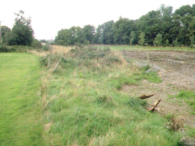
The trackbed runs in a straight
line from the caravan site to the Afon Gwyrfai bridge (UB56) just north of Salem. The route
was unfenced but was clear of obstruction The water main
begins at the Water Treatment works on the east side of the line.
This northerly view (24/8/02) from the public footpath at LC31 shows tracklaying completed. There is a little kink in the track at the l/c. Click on the image to enlarge. This image is copyright B W Hughes. Image taken on Samsung Digimax230 digital camera using iPhoto Plus4 image correction technology. Image displayed at 96dpi.
This southerly view from LC31 shows the former 'A frame' steps for the crossing lying on their side on the trackbed. Both of these had been removed to Dinas in a disassembled state by 9/2/02. The footpath continues south with the Waterworks behind. At this point there was a run round loop for the quarry branch that diverged to the left. Click on the image to enlarge. This image is copyright B.W.Hughes. Slide scan technology utilised is Olympus ES10 & iPhoto Plus4. Slide scanned at 200dpi.
This southerly view (24/8/02) from the public footpath over LC31 shows completed track along the back of the Waterworks. Click on the image to enlarge. This image is copyright B W Hughes. Image taken on Samsung Digimax230 digital camera using iPhoto Plus4 image correction technology. Image displayed at 96dpi.
Tramway Junction
This northerly view (15/9/01) shows the trackbed from the tramway junction pegged out for the new correct fence lines with yellow pegs. The campsite football pitch encroaches on the trackbed to the left and all trace of the fencing and formation has been removed. Work starts on this section in November. Click on the image to enlarge. This image is copyright B.W.Hughes. Slide scan technology utilised is Olympus ES10 & iPhoto Plus4. Slide displayed at 96dpi.
The 1m wide fenced slot for the footpath along the back of the Waterworks has been re-located. The original plan was to deviate the footpath at the old tramway junction, crossing onto Bryn Gloch campsite. However, the Water Authority has given up some of its land for the footpath. Consequently, LC31 moves back to its original position from Ch.7630 to Ch.7530, which is the position of the old A-frame rail-built stiles. These were removed to Dinas by 9/2/02.
The resulting 100m stretch of footpath parallels the railway and will provide interesting photographic locations, especially if Bryn Gloch Halt is eventually constructed between Ch.7300 and Ch.7500 as originally proposed.
This northerly view (22/10/01) shows the same view as that above. The trackbed is now fenced and clearance work was expected from the Cae Hywel bridge end during November. Click on the image to enlarge. This image is copyright B.W.Hughes. Slide scan technology utilised is Olympus ES10 & iPhoto Plus4. Slide displayed at 96dpi.
This northerly view (9/2/02) from the public footpath at LC31 shows the formation cleared and quarry waste added along the back of the Waterworks. Some excavation is visible to the left of the formation in association with the feeder water main. Click on the image to enlarge. This image is copyright B.W.Hughes. Slide scanned at 200 dpi using Olympus ES10 and iPhoto Plus4 image correction technology.
This northerly view (11/8/02) from the public footpath at the back of the Waterworks shows ballasting completed and steel sleepers laid out ready for tracklaying. Click on the image to enlarge. This image is copyright B W Hughes. Image taken on Samsung Digimax230 digital camera using iPhoto Plus4 image correction technology. Image displayed at 96dpi.

This northerly view (24/8/02) from the same viewpoint as above shows track laid along the rear of the Waterworks. Click on the image to enlarge. This image is copyright B W Hughes. Image taken on Samsung Digimax230 digital camera using iPhoto Plus4 image correction technology. Image displayed at 96dpi.

This southerly view (23/12/00) from the same point as that above, shows the trackbed from the tramway junction towards Salem bridge with Elephant Mountain in view. The fence in line with the post on the left marks the eastern side of the formation. Click on the image to enlarge. This image is copyright B.W.Hughes. Slide scan technology utilised is Olympus ES10 & iPhoto Plus4. Slide scanned at 200dpi.
This southerly view (22/10/01) shows the trackbed now fenced from the former tramway junction. In the distance can be seen two JCBs at Cae Hywel bridge, where an access track is being fenced off towards the main road. Click on the image to enlarge. This image is copyright B.W.Hughes. Slide scan technology utilised is Olympus ES10 & iPhoto Plus4. Slide displayed at 96dpi.
This southerly view (9/2/02) from the public footpath at LC31 shows the formation cleared and quarry waste added. Tros-y-Gol worksite is visible in the distance. The large excavation to the right may be connected with the water main feed to the Waterworks. Click on the image to enlarge. This image is copyright B.W.Hughes. Slide scanned at 200 dpi using Olympus ES10 and iPhoto Plus4 image correction technology.
This southerly view (11/8/02) from the public footpath at the rear of the Waterworks shows the Head of Steel at Ch.7645 at the end of the first weekend of tracklaying. Tracklaying should be complete on this isolated section to the end of ballast between OB54 and OB53 by the end of September. Click on the image to enlarge. This image is copyright B W Hughes. Image taken on Samsung Digimax230 digital camera using iPhoto Plus4 image correction technology. Image displayed at 96dpi.
Mineral Branch
There is a footpath
crossing at LC31 at the former junction of the Ystrad Iron Ore Mine branch,
which crossed the road immediately south of the Water Works. This was also the
outlet for Gareg Fawr Iron Ore Mines. The branch was closed in 1920 and lifted
in 1922 as the NWNGR section was rationalised for the WHR
opening.
This easterly view (23/12/00) shows the view from the
footpath of the former Ystrad tramway crossing of the main road immediately south of
the Waterworks. The 2 foot gauge feeder passed between the matching pair of
gateposts visible either side of the road. The levels of the mines are visible
rising up the hillside beyond. Click on the image to enlarge. This image is
copyright B.W.Hughes. Slide scan technology utilised is Olympus ES10 &
iPhoto Plus4. Slide scanned at 200dpi.
Cae Hywel worksite/Tros-y-gol
Pegging out of fence lines was apparent from this point (as seen above) south to the site of Cae Hywel bridge in the last week of August 2000 and to Plas-y-nant by the end of October.
This northerly archive view shows the trackbed running north in a shallow cutting towards Bryn Gloch caravan site from Cae Hywel bridge (UB56). The trackbed appears unusually wide here. The Water Treatment Works is on the right hand side of the formation. The access track to the main road is to the right but is not a public right of way. Click on the image to enlarge. This image is copyright B.W.Hughes. Slide scan technology utilised is Olympus ES10 & iPhoto Plus4. Slide scanned at 200dpi.
This northerly view (11/8/02) shows the start of the permanent track at Ch.7860 at Cae Hywel. Two lengths of temporary track have been laid to a rail store south of this point. Click on the image to enlarge. This image is copyright B W Hughes. Image taken on Samsung Digimax230 digital camera using iPhoto Plus4 image correction technology. Image displayed at 96dpi.

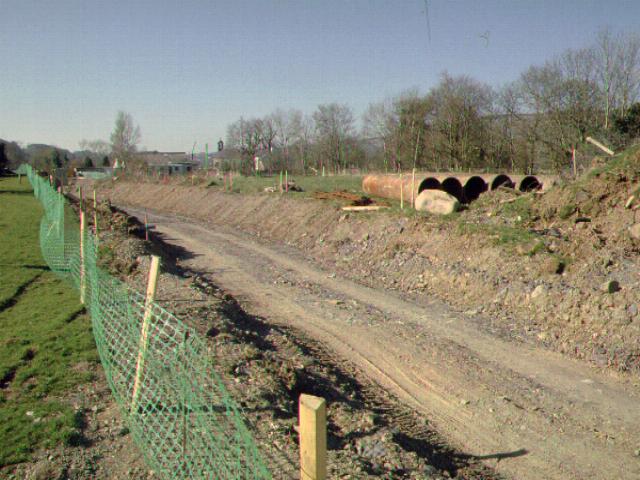
This southerly view (11/8/02), just north of Cae Hywel bridge (UB56), shows the rail stack at Tros-y-gol worksite. Two lengths of temporary track lie alongside the rail stack to ease transfer to RRMs. The alignment is temporarily diverted around the stack and should make a straight line to the bridge in the background. Click on the image to enlarge. This image is copyright B W Hughes. Image taken on Samsung Digimax230 digital camera using iPhoto Plus4 image correction technology. Image displayed at 96dpi.
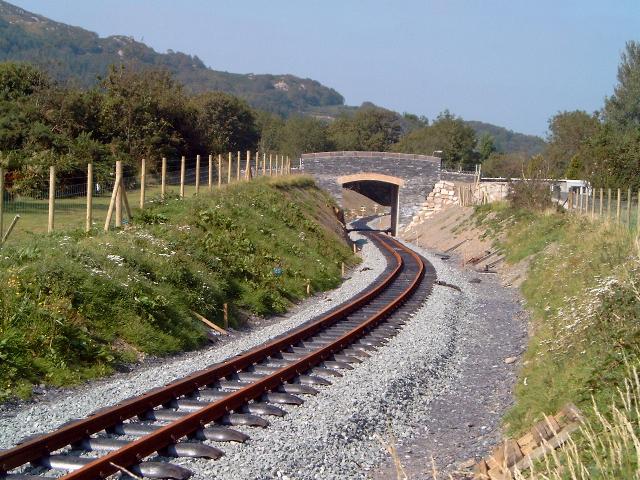
UB56 Cae Hywel bridge
This bridge is a similar bowstring
girder and has been left in place as a local resident is using it rather than
the adjacent ford to the west. It is currently planked across its full width.
One previously proposed system was more sophisticated than rods through the structure with plates at the ends. It involved coring through the structure or into the structure and inserting an impermeable fabric stocking which would then inflated with a chemical grout so that the hole and most of the adjacent voids were filled.
A reinforcing rod could also be installed and subsequently tensioned if required. The bolt end could be recessed into the stone work and the hole plugged with a stone core.
The advantage of the system would be that it helped to glue the structure together and spread the loads rather than creating point loadings. The grout would be contained and the tendency for pressure grouting to force the structure apart in an uncontrolled fashion eliminated.
However, a new bridge is to be constructed and the existing bridge girders will be reused on new re-inforced concrete abutments, clad with local stone. It appears that an improved overflow channel will be constructed on the south side. The bridge deck was lifted out in November and stored at Cae Hywel awaiting new steelwork cross members.
Access to the trackbed south from here is now via the adjacent low lying pipe bridge that becomes a ford when the river floods.

This southerly archive view shows UB56, the Gwyrfai Bridge, where the railway crosses from the east to the west bank. The bridge is a bowstring girder structure like the one recently removed from Betws Garmon. A further bridge of the same type is in situ at Plasynant Halt about 1 km south of this location. Click on the image to enlarge. This image is copyright B.W.Hughes. Slide scan technology utilised is Olympus ES10 & iPhoto Plus4. Slide scanned at 200dpi.
Full details of the refurbishment of this bridge will be found on the next page.
Click here to visit the Salem-Plasynant page
Click here to return to Stop Press page
Site Development
If you have suggestions for development of this site, please contact me by email at the address on the Stop Press page.
Comments
Please add comments in my Guestbook.
Page Version 3.33 Dated 4/7/03