WHR
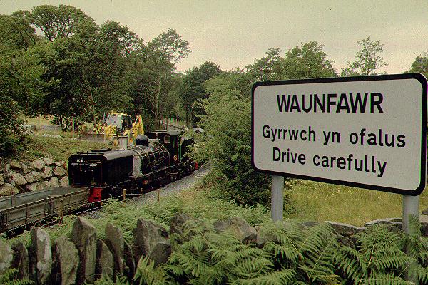
Waunfawr
area page
V2.12 updated 21/10/2000
New images on this page updated 16/9/00.
Click here for start of new images
Click here for JC Sreeves latest construction map
Waunfawr locations
The A4085 crosses the line at Waunfawr station OB42 at Ch 5530. There are no other public locations. However, customers of the Snowdonia Parc hotel/campsite may view the line from its premises, which includes a large car park alongside the route and the caravan site access road, which crosses the headshunt. The line is level approaching Waunfawr along the Afon Gwyrfai valley but under the A4085 road bridge the gradient increases to 1 in 120 through the station.
This view taken on 3/7/99 from the A4085 road bridge shows the exploratory works that were conducted at Waunfawr within weeks of the announcement of the TWO. The station building was still standing at this time and the ballast bed of the two tracks through the station can be seen. The new station will feature a wide island platform with the northbound track on the left sweeping through the site of the station building. A new longer station building will be constructed slightly to the right in a central position in the new platform. By the end of September, the station building was demolished and stored. Click on the image to enlarge. This image is copyright B.W.Hughes. Slide scan technology utilised is Olympus ES10 & iPhoto Plus4. Slide scanned at 200dpi.

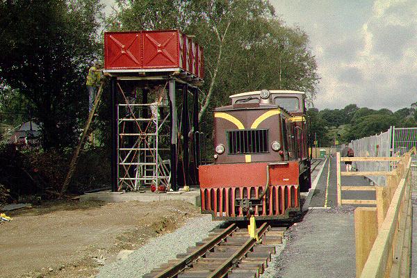
This northerly view (16/9/00) from Waunfawr station l/c shows Taliesin and Mountaineer running round their train through the newly completed run round loop. The fenced path from the platform to the l/c will become the disabled access once the footbridge is completed this winter. The water tower was still not in use at this time and a temporary ground level tank with a pump was provided as previously operated on Dinas platform. Click on the image to enlarge. This image is copyright B.W.Hughes. Slide scan technology utilised is Olympus ES10 & iPhoto Plus4. Slide scanned at 200dpi.
Bridgeworks OB42
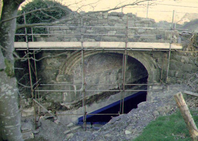
Mulcair's team was engaged for Bridge Contract I to underpin Waunfawr bridge and other bridges to Tryfan Junction, where Contract II commences. Work started in October and was almost complete by the end of the year. Waunfawr bridge required deepening by about 1 metre to meet the increased loading gauge. The drop will be worked out over 20 metres either side of the bridge. The bridge foundations were excavated and concrete used to underpin and extend the depth of these. RSJs were used to cross brace the sheeting formwork.

This view looking east towards Waunfawr station limits was taken on 18/9/99 on the official trackbed walk. Work began in October to underpin the foundations and reinforce and extend the wing walls. Click on the image to enlarge. This image is copyright B.W.Hughes. Slide scan technology utilised is Olympus ES10 & iPhoto Plus4. Slide scanned at 200dpi.
This easterly view (18/3/00) shows the 30 cm thick reinforced invert complete. The invert is painted blue and sealed with black water repellent materials. The dark line on the bridge wall is the former ground level of OB42. Scaffolding was in place to allow pointing of the stonework for the parapets. The pipe that drains the station area is seen emerging from the concrete on the RHS. Click on the image to enlarge. This image is copyright B.W.Hughes. Slide scan technology utilised is Olympus ES10 & iPhoto Plus4. Slide scanned at 200dpi.
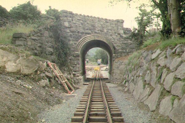
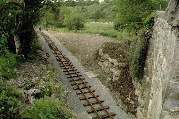
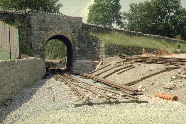
This southerly view (15/7/00) shows the track laid through OB42 at Waunfawr, now known as WHR 27 by requirement of the HMRI. The track is laid in wooden sleepers to allow checkrails to be added because of the limited clearance. The nearest length was lifted after first being laid with steel sleepers and the ballast reduced to 150 mm compared to the 250 for steel sleepers. The decision to take the wooden sleepers to Ch. 5320 near Cyrnant was late in the day due to non-availability of certain sizes of gauge setting rail clips for the steel sleepers. Click on the image to enlarge. This image is copyright B.W.Hughes. Slide scan technology utilised is Olympus ES10 & iPhoto Plus4. Slide scanned at 200dpi.
Waunfawr cutting
This view (20/12/99) shows the boulder support provided to the west bank of the deepened cutting approaching the A4085 bridge. In the background are the erosion protection works. Spare rock was being moved to the station area by the dumper truck. Click on the image to enlarge. This image is copyright B.W.Hughes. Slide scan technology utilised is Olympus ES10 & iPhoto Plus4. Slide scanned at 200dpi.

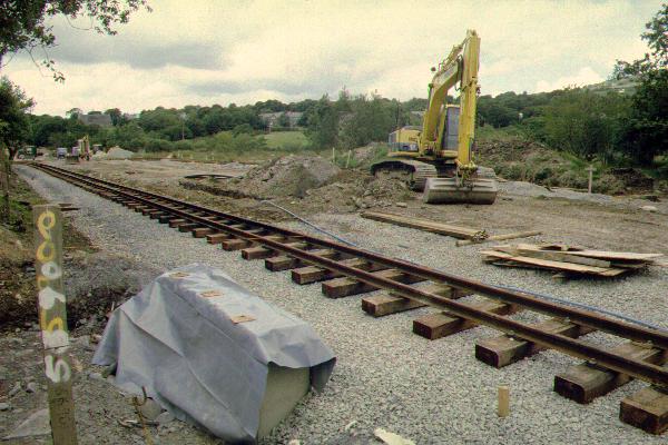
This similar view (22/1/00) shows progress with drainage in Waunfawr cutting and the provision of a slate waste plant road. Manholes are being cast for the station drainage system, which runs along the near side of the line. In the distance, rectangular sections of culverts are seen and rock fill stored to improve the track sub-base. The trackbed is now at its final level and slopes downhill towards the viewpoint. Click on the image to enlarge. This image is copyright B.W.Hughes. Slide scan technology utilised is Olympus ES10 & iPhoto Plus4. Slide scanned at 200dpi.
This westerly view (10/6/00) shows three panels of track laid in Waunfawr cutting. The furthest panel had been removed by 1/7/00 to allow the trackbed to be regraded and rolled flat. Ballast now extends from this point to Ch. 5371 with works approaching Cyrnant from both directions. Click on the image to enlarge. This image is copyright B.W.Hughes. Slide scan technology utilised is Olympus ES10 & iPhoto Plus4. Slide scanned at 200dpi.
This westerly view (31/7/00) shows Upnor Castle on a ballast train late in the evening. Track had been linked into the station two weeks previously. Upnor Castle had just propelled the failed Stephcomatic tamper into the station while the ballast wagons were loaded at Cyrnant. Click on the image to enlarge. This image is copyright B.W.Hughes. Slide scan technology utilised is Olympus ES10 & iPhoto Plus4. Slide scanned at 200dpi.
This westerly view (2/8/00) shows the first visit of a steam loco to Waunfawr since 1938! NG/G16 No.143 was sandwiched between Upnor Castle and Conway Castle as clearance tests were done at every bridge between Dinas and Waunfawr. Click on the image to enlarge. This image is copyright B.W.Hughes. Slide scan technology utilised is Olympus ES10 & iPhoto Plus4. Slide scanned at 200dpi.
Waunfawr Station
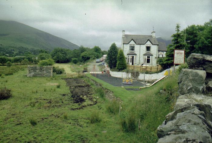
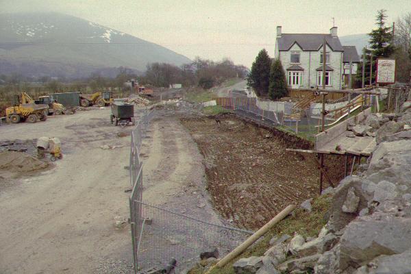
Waunfawr station works were commenced as early as July and the station building was demolished in September. The building needs to be repositioned on an island platform with footbridge access. The stones and yellow bricks used for decorative window and door surrounds were carefully marked for use in the new expanded station building which will faithfully represent the style of the former structure. Work is complicated by the presence of a sewer crosses the middle of the site at right angles and also the Caernarfon water main which passes close alongside the east side of the site.
This easterly view (8/3/00) shows the excavation of the trackbed over some tens of metres southeast from the bridge to allow the newly constructed Garratt clearance dip under the bridge to be run out. The station building will be on the island platform and the footbridge will be constructed to the pub car park just beyond the pub building. The pub car park is being extended for joint use in agreement with the owners who stand to benefit from created trade. However, work has still not taken place to remove the pub cesspit that crosses the site near the pub building. Click on the image to enlarge. This image is copyright B.W.Hughes. Slide scan technology utilised is Olympus ES10 & iPhoto Plus4. Slide scanned at 200dpi.

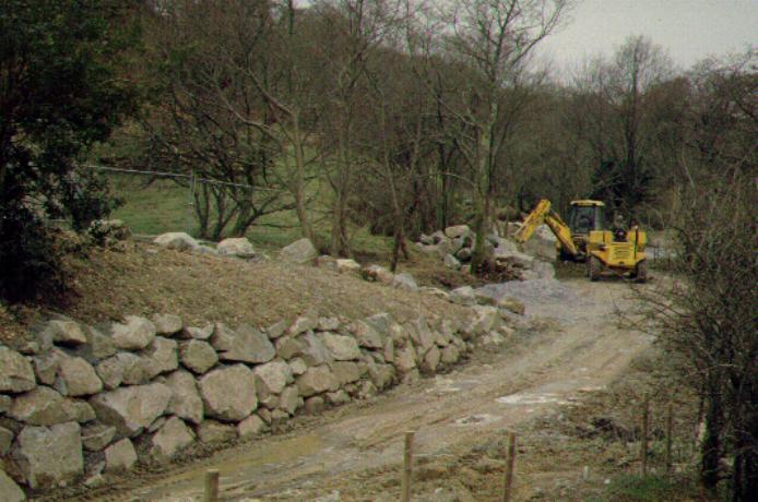
This easterly view (6/5/00) shows the wall being erected to support the pub's play area. This work, in common with other work at Waunfawr, is being progressed by local contractors. A large glacial boulder became apparent in the excavations and work was halted for a week until this was broken up by a chemical expansion charge on the evening of 26/4/00. Explosives could not be used due the proximity to the pub. The opportunity was also used to break up a rock protruding into the loading gauge near the bridge portal. The JCB is seen removing the shattered rocks. With the clearance of these obstructions, the main station drain can be completed and trackbed preparation for the loop begun. Click on the image to enlarge. This image is copyright B.W.Hughes. Slide scan technology utilised is Olympus ES10 & iPhoto Plus4. Slide scanned at 200dpi.
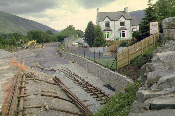
This southerly view (10/6/00) shows the point laid in at Waunfawr. The formation of the southbound track can be seen clearly curving to the right and following the wall. The JCB is positioned on the northbound track. A wide island platform will separate the two tracks although facilities will follow over the winter closure period. Some thirty rails have been moved to the Waunfawr rail store, visible bottom left. Three lengths are laid towards Dinas under the bridge with two on wooden sleepers to allow checkrails. Click on the image to enlarge. This image is copyright B.W.Hughes. Slide scan technology utilised is Olympus ES10 & iPhoto Plus4. Slide scanned at 200dpi.
(W34)
This southerly view (1/7/00) shows the track laid along the southbound running line (FR practice of RH running will be adopted) along the west side near the hotel. Additional track materials are piled ready to extend the track towards the headshunt. The formation of the northbound loop is visible fully ballasted, though obstructed by track materials piled near the point. After the end of season, a footbridge will be erected to give access from a location on the island platform to a point just behind the hotel, where the station car park will be. A works siding will also be installed on the site of the former coal yard (extreme left). In due course this will become a permanent feature, as in the original station. Initially it will be used to extend track over Phase 3. Click on the image to enlarge. This image is copyright B.W.Hughes. Slide scan technology utilised is Olympus ES10 & iPhoto Plus4. Slide scanned at 200dpi.
This southerly view (15/7/00) shows the loop being laid at Waunfawr. The rail store is currently over the position of the northbound track (LH). Wooden sleepers are the rule throughout Waunfawr for aesthetic reasons. RRMs are being used rather than the Dolgarrog Simplex. The wide width of the island platform will accommodate the lengthened station building utilising original stonework numbered and stored since September last year. It is intended to open the station on July 31st, all being well. At that time one platform face will be completed and tarmaced (the right hand face). Click on the image to enlarge. This image is copyright B.W.Hughes. Slide scan technology utilised is Olympus ES10 & iPhoto Plus4. Slide scanned at 200dpi.
This southerly view (31/7/00) shows Upnor Castle checking clearances along the newly installed southbound platform face after shunting the failed Stephcomatic tamper into the siding (later to be the run-round loop). Click on the image to enlarge. This image is copyright B.W.Hughes. Slide scan technology utilised is Olympus ES10 & iPhoto Plus4. Slide scanned at 200dpi.
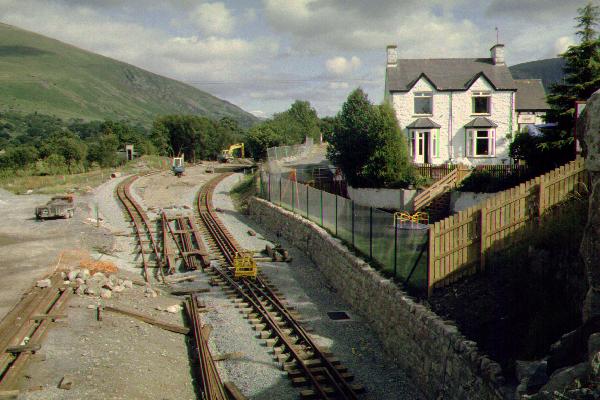
This westerly view (18/6/00) shows the point in place at Waunfawr with track rising steeply into the station. The point had been carefully aligned so that the platform faces could be erected after the track was laid out. This procedure was decided on after the Caernarfon experience, where the south end of the platform had to be rebuild when it was found it did not match the curvature of the track which appeared afterwards. By 1/7/00 track extended along the left-hand side (southbound track) to Ch. 5639, some 120 metres. The island platform is taking shape and both trackbeds were prepared up to the caravan site l/c. The left-hand track is fully ballasted though some ballasting remains on the right hand track. Click on the image to enlarge. This image is copyright B.W.Hughes. Slide scan technology utilised is Olympus ES10 & iPhoto Plus4. Slide scanned at 200dpi.
This westerly view (2/9/00) shows Castell Caernarfon hauling the full six coach rake into the station at Waunfawr with No. 143 in the siding. Within two weeks, the loop was complete and this loco was no longer stabled at Waunfawr during the day. The initial loaded shunt manoeuvre had been abandoned by the Bank Holiday and the steam loco detached outside the station to allow the Funkey to shunt out, couple up and draw the train into the platform. Click on the image to enlarge. This image is copyright B.W.Hughes. Slide scan technology utilised is Olympus ES10 & iPhoto Plus4. Slide scanned at 200dpi.
Waunfawr South
This northerly view (15/7/00) shows the works in progress on that day to build the footings at Ch. 5690 for the new station footbridge. The steelwork will be erected in the closed season. The current work is being done in advance so as not to disturb the track after running starts. The station buildings will be to the north of this point. Click on the image to enlarge. This image is copyright B.W.Hughes. Slide scan technology utilised is Olympus ES10 & iPhoto Plus4. Slide scanned at 200dpi.
This northerly view (10/6/00) shows the two trackbeds and the island platform between them. Both were ballasted at this point by 1/7/00. Fortunately, the original NWNGR formation was unusually wide at this point allowing the platform to extend up to 200 metres to the south without additional land take or excavation. Access to the platform will initially be from the L/C until the footbridge from the pub is put in place this winter. A siding is to be constructed for construction train purposes on the right hand side when Phase 3 begins after the 2000 operating season comes to an end. Click on the image to enlarge. This image is copyright B.W.Hughes. Slide scan technology utilised is Olympus ES10 & iPhoto Plus4. Slide scanned at 200dpi.

This northerly view (1/7/00) shows good progress north of LC22. Both tracks are now ballasted and the shape of the island platform is clear between them. Until the footbridge is put in place over Xmas, access will be from the l/c onto the island platform at this location. For Phase 3, a siding will be put in place at Xmas for a works train on the northbound (RH) road with the turnout just beyond the end of the trees. Click on the image to enlarge. This image is copyright B.W.Hughes. Slide scan technology utilised is Olympus ES10 & iPhoto Plus4. Slide scanned at 200dpi.

This northerly view from the island platform shows the track laid to the middle of the station at Ch. 5639. Wooden sleepers are being used throughout the station as they will blend in with the classic appearance of this station, which is to be recreated by using the original building stones and extended using similar materials. Click on the image to enlarge. This image is copyright B.W.Hughes. Slide scan technology utilised is Olympus ES10 & iPhoto Plus4. Slide scanned at 200dpi.

This northerly view (3/8/00) shows Upnor Castle ballasting in Waunfawr platforms with Conway Castle to the rear. The following weekend, a North Wales Group working party tamped the length and made a tidy job. The concrete footings for the footbridge (to be constructed this Winter) can be seen completed to the left of the loco. The Stephcomatic tamper was still stabled in the incomplete run round loop at this time. Click on the image to enlarge. This image is copyright B.W.Hughes. Slide scan technology utilised is Olympus ES10 & iPhoto Plus4. Slide scanned at 200dpi.
This northerly view (27/8/00) shows Castell Caernarfon locked between two track clamps at the south end of the platform awaiting duty as shunt engine at Waunfawr. This practice ceased with the completion of the loop on 9/9/00. The temporary ground level water tank was still in use during the Gala on 16-17/9/00. As the platform was incomplete, fencing leaves a two metre wide platform on the northbound platform. The platform and loop was fully opened on 9/9/00. Click on the image to enlarge. This image is copyright B.W.Hughes. Slide scan technology utilised is Olympus ES10 & iPhoto Plus4. Slide scanned at 200dpi.
Waunfawr Headshunt
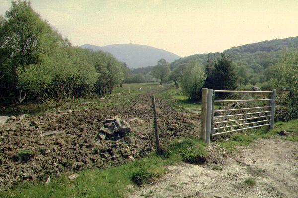
This southerly view (6/5/00) shows initial clearance works at Waunfawr headshunt from LC22. The southern loop point will be this side of the l/c. Work started at this location in May and extends as far as LC23 (Ch 5880), the start of Phase 3. The Nant-y-Betws Pass is visible in the distance. It is hoped locos will run round here from July. Click on the image to enlarge. This image is copyright B.W.Hughes. Slide scan technology utilised is Olympus ES10 & iPhoto Plus4. Slide scanned at 200dpi.

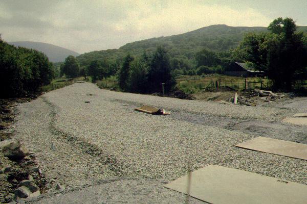
This southerly view (1/7/00) shows the headshunt area fully cleared and hardcore for the new LC22 laid across just south of the existing caravan park crossing. The gate in the distance marks the start of Phase 3 where work will commence in August. Click on the image to enlarge. This image is copyright B.W.Hughes. Slide scan technology utilised is Olympus ES10 & iPhoto Plus4. Slide scanned at 200dpi.
(W37)
This northerly image (15/7/00) shows the trackbed consolidation in the headshunt at LC23 at approx. Ch. 5900. Slate fines have been laid and compacted with vibrator-rollers. Track was due to be laid here within seven days. Click on the image to enlarge. This image is copyright B.W.Hughes. Slide scan technology utilised is Olympus ES10 & iPhoto Plus4. Slide scanned at 200dpi.
By 24/7/00, ballast had been laid and the extended parallel track section south of LC22 became apparent. The purpose of this is unclear as the platform does not extend south of the l/c. Click on the image to enlarge. This image is copyright B.W.Hughes. Slide scan technology utilised is Olympus ES10 & iPhoto Plus4. Slide scanned at 200dpi.
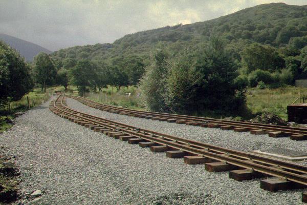
This southerly view (27/8/00) shows the completed track south of LC22. The point is near LC23, just before Ch 5900. Click on the image to enlarge. This image is copyright B.W.Hughes. Slide scan technology utilised is Olympus ES10 & iPhoto Plus4. Slide scanned at 200dpi.
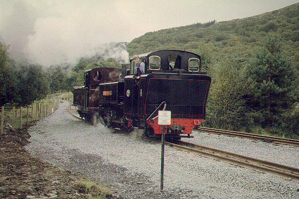
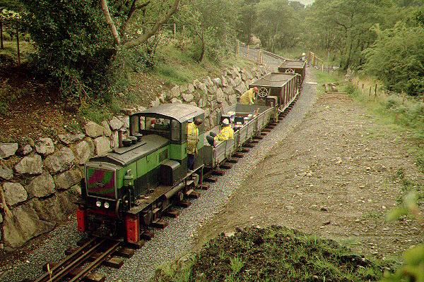
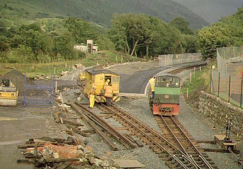
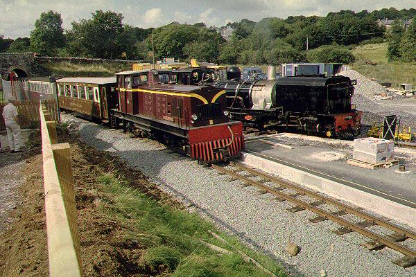
This southerly view (16/9/00) shows Mountaineer and Taliesin running round in the Waunfawr headshunt. The tracks run parallel for some way south of the l/c. Click on the image to enlarge. This image is copyright B.W.Hughes. Slide scan technology utilised is Olympus ES10 & iPhoto Plus4. Slide scanned at 200dpi.
The way ahead
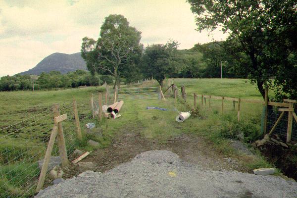
This southerly view (15/7/00) shows the way ahead from the Waunfawr headshunt, viewed from the same spot as that above. Work starts here in October to extend the line to Rhyd Ddu for opening in 2003. Click on the image to enlarge. This image is copyright B.W.Hughes. Slide scan technology utilised is Olympus ES10 & iPhoto Plus4. Slide scanned at 200dpi.
Click here to visit the Task Ahead page
Click here to return to Stop Press page
Site Development
If you have suggestions for development of this site, please contact me by email.
Comments
Please add comments in my Guestbook on the homepage.
Page Version 2.12 Dated 21/10/00